One parcel in. A full pre-development workspace out.
Bring an address or a TMK. KILO reads the parcel across every axis a Hawaiʻi deal turns on, names the approvals it routes through, and carries the project with you through permitting — with the reasoning shown and every finding cited to its public source.
Most land risk in Hawaiʻi surfaces late — after the purchase or the permit, when the schedule and the budget are already committed. KILO reads the parcel before the decision, in minutes. You bring the parcels; KILO brings the read.
From a parcel to a permit, on one surface.
Bring a parcel
An address or a TMK, on any island — or a California parcel, in beta. Or bring a list — your own saved-search alert, your broker's, or a screen you ran.
Read it
Every domain the deal turns on, one cited verdict — worst tier wins — plus the cultural-resource band with its reasoning, and what could not be checked, stated on its face.
Work it
Promote the parcel to a project. The approvals it routes through become tracked filings with clocks, checklists, and agency comments.
Stay current
A daily digest and an in-app record whenever the public record moves on your parcels, your areas, or your open filings.
Start on the map. Read any parcel.
Every plan starts here — and so does the read a new account includes: an island map with the public layers the read draws on, and a cited read on the parcel you open.
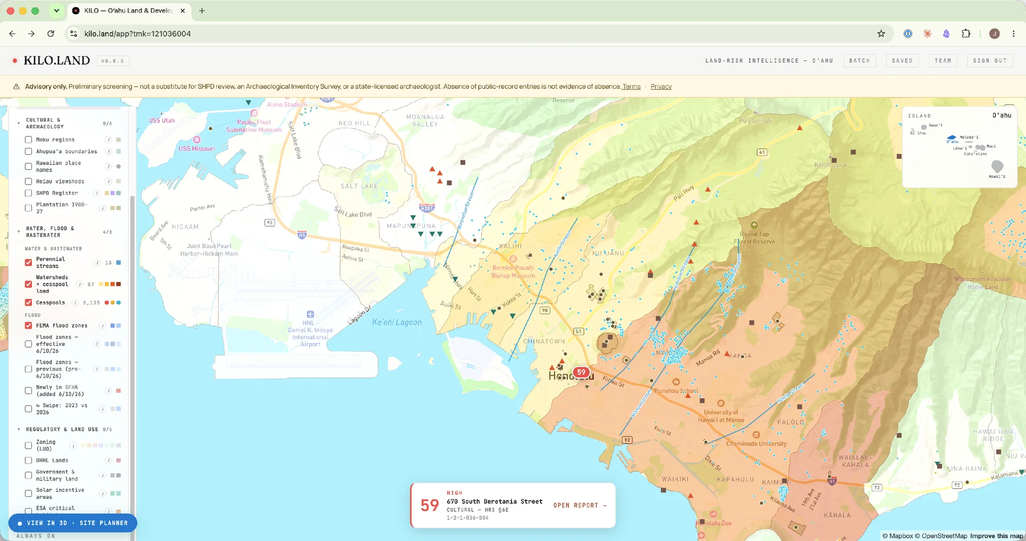
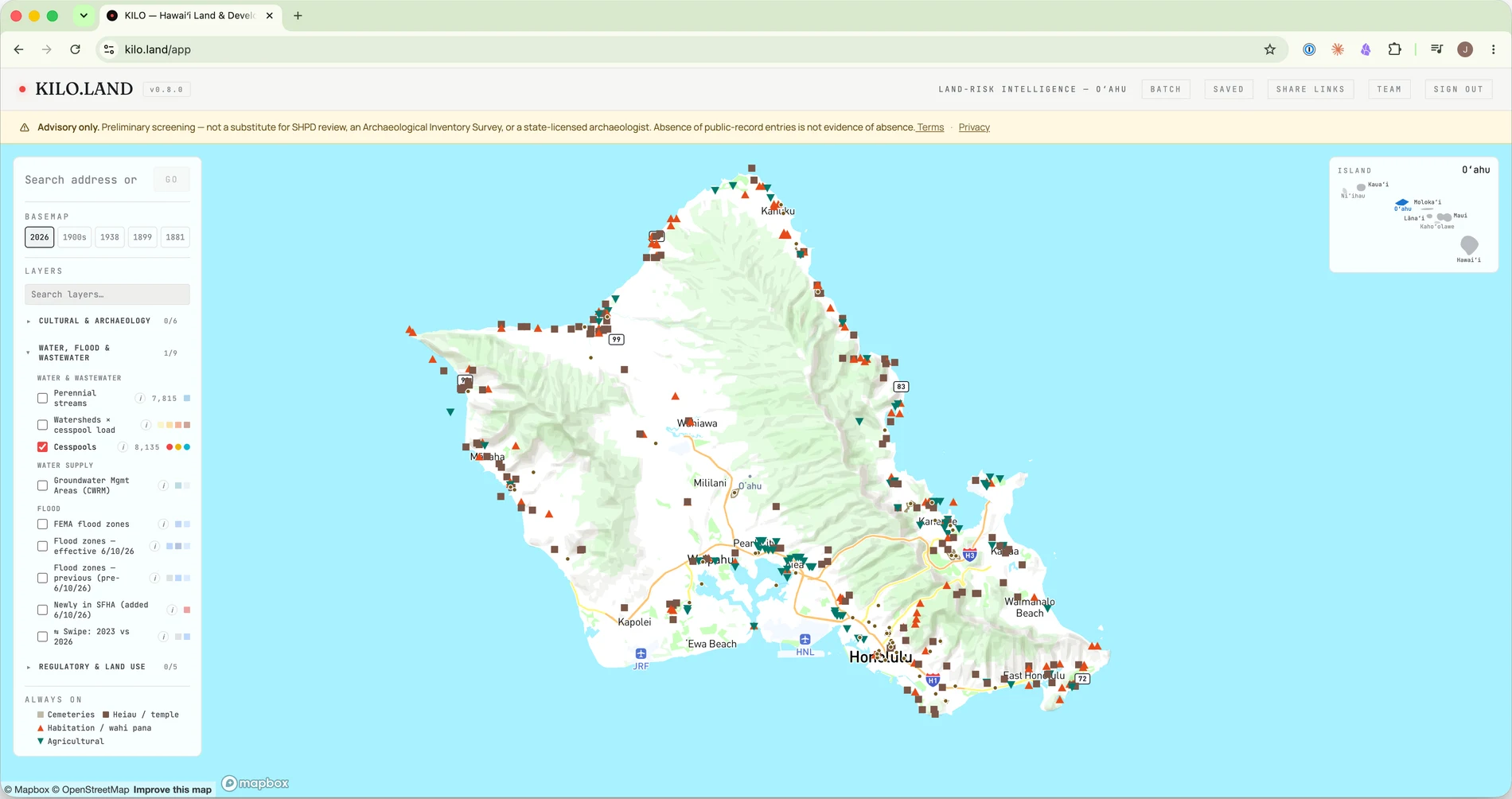
An island map with the public layers behind the read.
Toggle the public layers the read draws on — FEMA flood and the 2026 FIRM update, cesspools and wastewater, tsunami and wildfire, zoning, historic maps from 1881 to 1938, and the State's public historic register — from the agencies that publish them, across all four counties.
- Open a parcel and its band rides that pin — only the parcel you open is read, and the report is one click away.
- Layers from the public agencies that publish them — refreshed weekly, cited to the source.
- Statewide — Oʻahu, Maui, Kauaʻi, and Hawaiʻi Island.
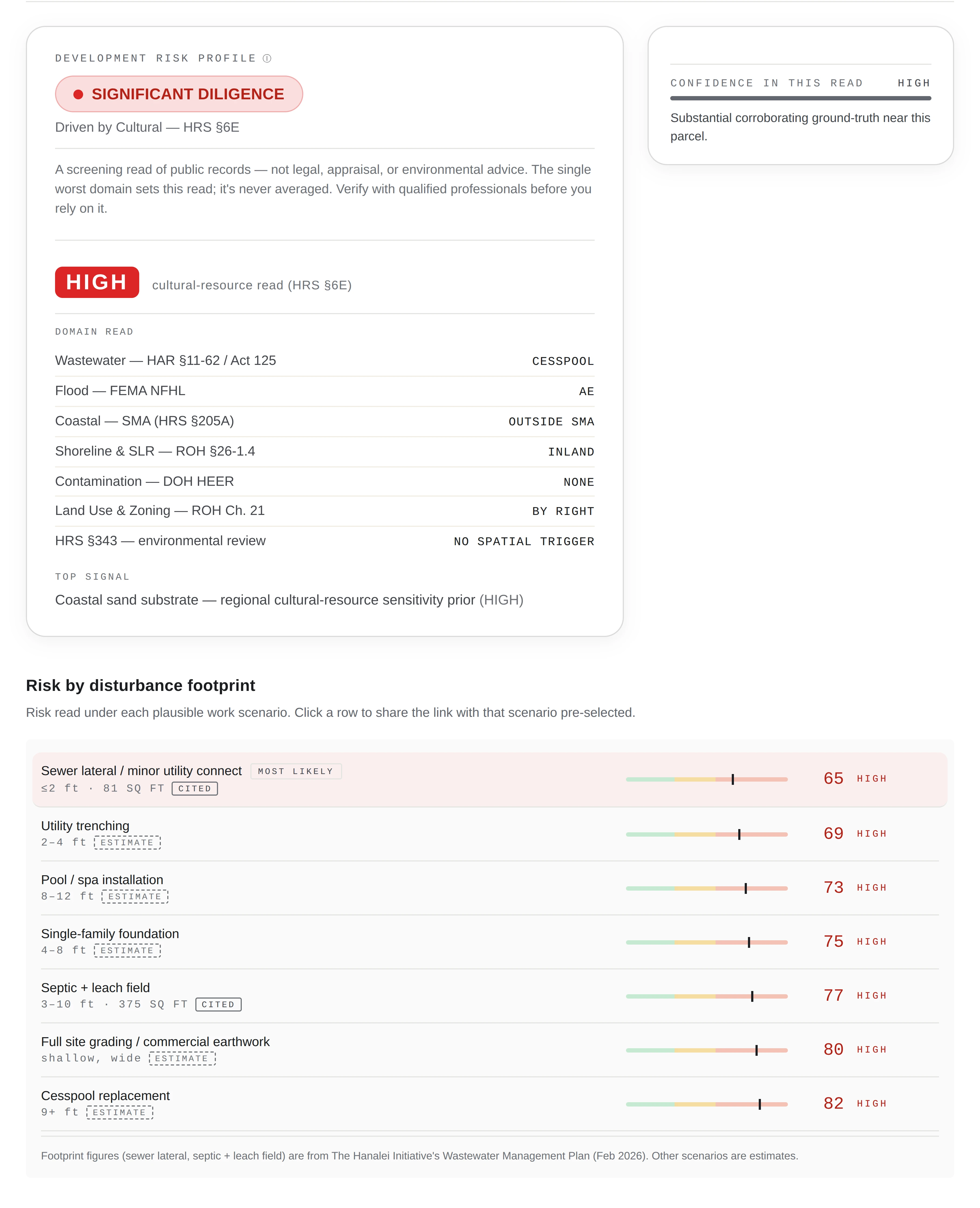
A cited verdict, every domain named, and the reasoning behind it.
The answer first — the cross-domain diligence verdict, the cultural-resource band, and every other domain named with its own finding beside it — then the six decision questions answered, each traced to the public dataset behind it. A screening read that tells you where to look, never a clearance.
- Score by disturbance footprint — the read for each plausible work scenario, sized to what you'd actually build.
- Sourced throughout — findings name the agency dataset behind them, with statute and record links where the source publishes one.
- Honest about absence — a low read is never proof a parcel is clear; what could not be checked is stated on the page.
- Cultural & historic · HRS §6E
- Land use & zoning · county code
- Wastewater · cesspool / sewer
- Contamination · HDOH / EPA
- Flood · FEMA NFHL
- Coastal permit · SMA
- Shoreline setback · county code
- Environmental review · HRS §343
Worst tier wins, and the verdict is a label, not a number. Each domain keeps its own band and its own reasoning — never collapsed into one go / no-go score.
A new account signed up with Google includes one read on the house, good for 14 days — the band, the cross-domain verdict, what could not be checked, and what to be ready for. The reasoning below it comes with a purchased assessment ($50) or a plan.
California, in beta. The same map and the same read, narrower and labeled as such: no score, no cultural read, and every limit printed on the report itself. What the beta covers →
A per-domain read, no score
Entitlement, seismic, fire, tsunami, flood, coastal zone, farmland, wetlands, critical habitat, contamination and environmental review, each with its own band, what was checked, and a next step — the parcel's identity and an at-a-glance list first. County zoning is read on unincorporated land in thirteen counties and inside the City of Los Angeles; elsewhere it reads as not read. Where USGS PAD-US records federal land, the zoning line names the managing agency instead of a county zone, and it says whether the parcel sits inside one of Caltrans's mapped High Quality Transit Areas. The fire line carries CAL FIRE's mapped burn history, and on Solo and above the energy panel adds substation and transmission distances. Every read lists the building footprints FEMA's USA Structures inventory maps on the parcel, each with the date of the imagery it was traced from. This week's US Drought Monitor class sits beside the read, dated to its map. The cultural line is the process a project will be asked to run, never a finding.
A map that switches to California
Pan over California and the map follows: California basemaps, including USGS topographic editions, and the State's own overlays — Alquist-Priolo fault traces, landslide susceptibility, the tsunami hazard area and Fire Hazard Severity Zones — beside FEMA flood. Display layers; the read still comes from the parcel.
Export it, share it
Every full California read exports to PDF with its citation stamp, and Solo and above can watch it, run it in a batch, attach it to a project and export it as a Due Diligence Brief or a Presentation Summary deck. The Kilo+ assistant stays Hawaiʻi-only for now.
Find the parcels that fit. Then read each one.
The market screener searches the statewide parcel dataset on the market and regulatory facts you underwrite on and hands you a bounded, ranked list. The cultural read stays a per-parcel step — it is not a criterion, and the dataset behind the screener carries no cultural column at all.
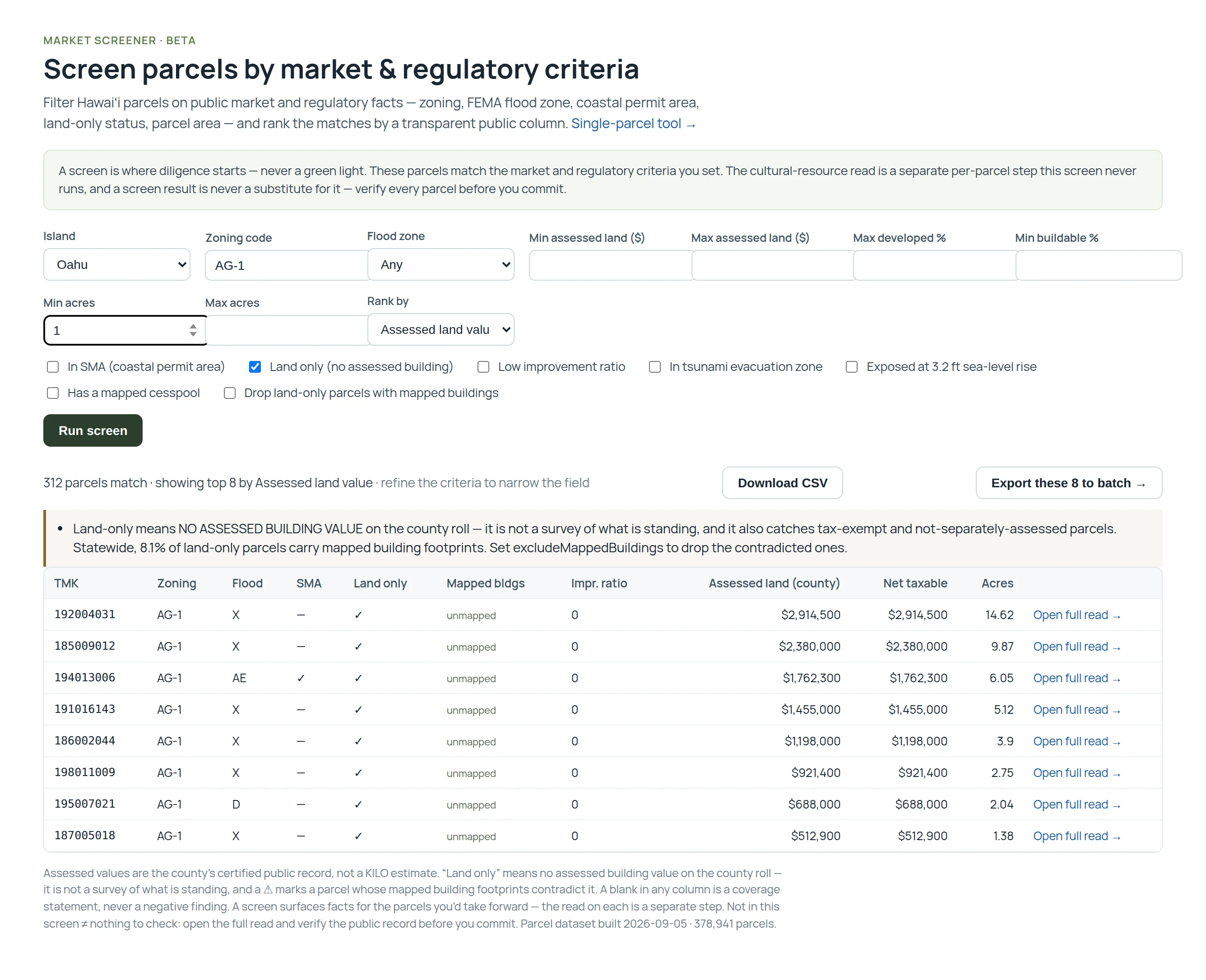
Screen Hawaiʻi parcels by the criteria you underwrite on.
Island, zoning code, FEMA flood zone, coastal permit area, tsunami zone, sea-level-rise exposure, mapped cesspool, land-only status, parcel area, assessed land value, improvement ratio, developed and buildable share — ranked by a public column you choose. Every figure is the county's own record: no composite score, no KILO value estimate.
- Download the screen as a CSV — its caveats and the dataset's build date travel as header lines.
- Send the results straight to batch, then open the full read on the ones you'd take forward.
- A screen that could not run says so — never an empty list you could mistake for an answer.
Saved screens
Filter the parcels you brought by market and regulatory bands — entitlement tier, flood zone, wastewater, SMA, environmental review — and save the criteria as a named screen you can re-run. The cultural read is deliberately not a screenable field.
Acquisition criteria & the criteria memo
Save your own acceptance thresholds as a named set and every parcel you read answers them one by one: meets, does not meet, or not verifiable — each line citing the field it was read from. Print a one-page criteria-vs-findings memo per parcel, with a verdict line you write yourself.
Batch assessment
Paste a CSV of TMKs and KILO reads all of them — the list you brought, read in one pass and ranked by the diligence each parcel demands, worst tier first. Screen the results by market and regulatory bands; the cultural read is never a filter.
Then carry the parcel through to permit.
The read names the approvals a parcel routes through and the order they happen in. Promote a parcel to a project and that pathway becomes something you can work: filings against real dates, the submittal content for each one, the agency comments and your responses, and the conditions of approval once you have them.
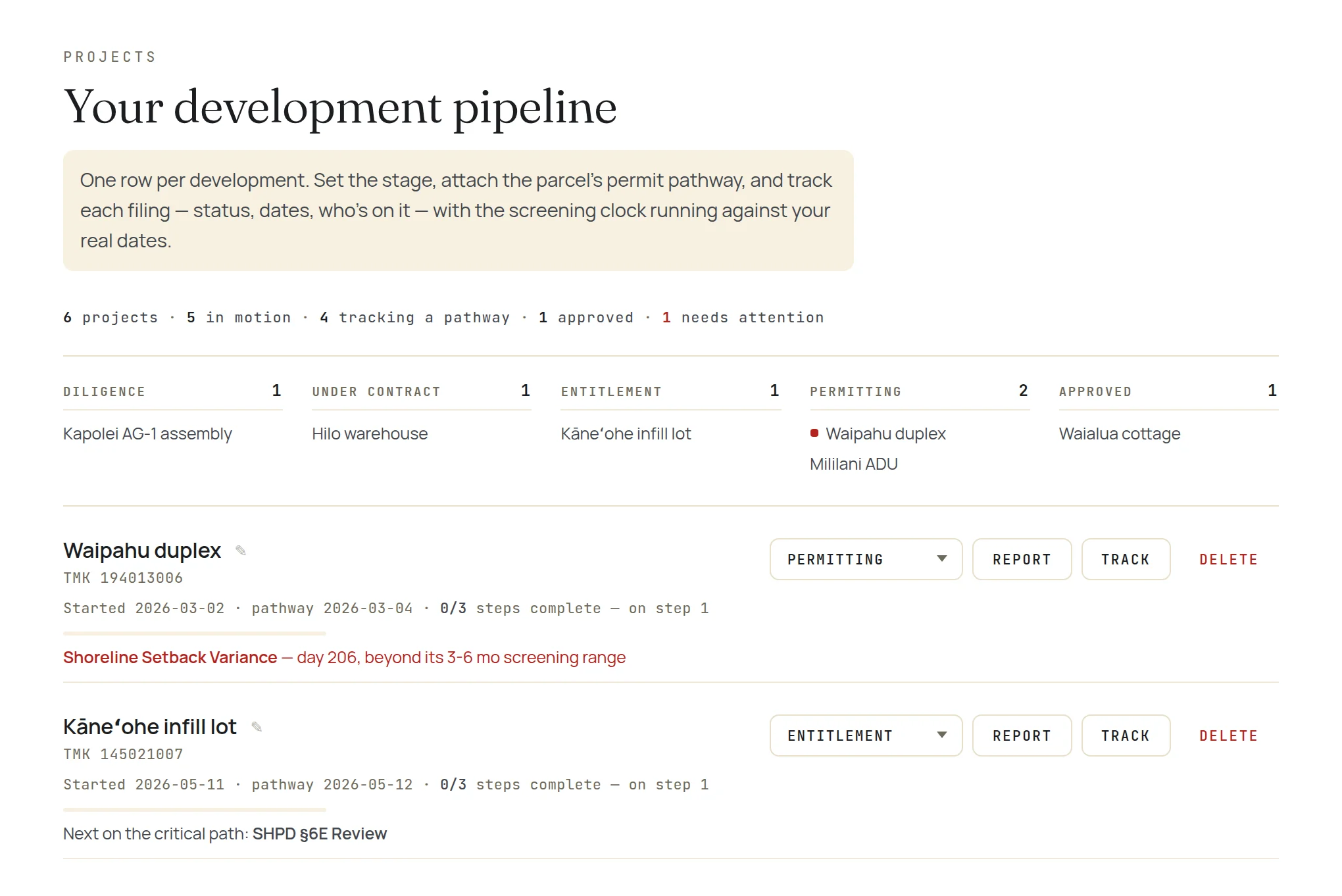
A pipeline board, and a clock on every open filing.
From two projects on, the workspace opens as a board — a column per stage from diligence to approval, a mark on anything needing attention, and a one-line pulse per project: the filing that has run long, the open agency comment, or simply the next step on the critical path.
- Review clocks run against the screening range for each instrument, so a slow review is a fact, not a feeling.
- One shared pipeline on Studio and Team — every seat sees the firm's projects on one board, owner named, editing with the owner.
- Your projects as pins on the same statewide map you read parcels on.
Submittal checklists, cited
28 instruments carry a check-off list of what the agency actually requires, each item verified against the adopted rule text and cited to it — the permit spine, the short-term-rental registrations, and the discretionary instruments, including the zoning variance in all four counties.
Agency comments & responses
Log what the agency returned on a filing and what you sent back, per step, with open items flagged until they're resolved — then print the whole comment-and-response record when the reviewer asks for it.
Conditions of approval
Paste your determination letter and KILO segments it into conditions, each carrying the page it came from. A condition with a deadline becomes a tracked date in the digest; one without an anchor says the date can't be computed rather than inventing it.
CivCheck, under the parcel
DPP requires its CivCheck pre-check on most residential building-permit applications from September 1, 2026. The pathway asks the one question the parcel can't answer — your scope of work — answers from DPP's own lists, carries the zoning facts the pre-check will ask for — and, in Projects, holds your CivCheck ID so the permit never reads “ready to file” with the question open.
The diligence hand-off
The report routes each open question to the professional who answers it — surveyor, civil engineer, land-use attorney, and where §6E review attaches, a qualified archaeologist — with the agency offices and the records requests alongside. One click turns the list into a tracked checklist.
What permits actually took
Beside the statutory window, the observed record: across 2,898 new-construction applications filed 2019–2021, the median ran about 12 months and 35% were not issued within two years. The gap is the schedule risk a pro forma carries.
The public record moves. KILO keeps watching.
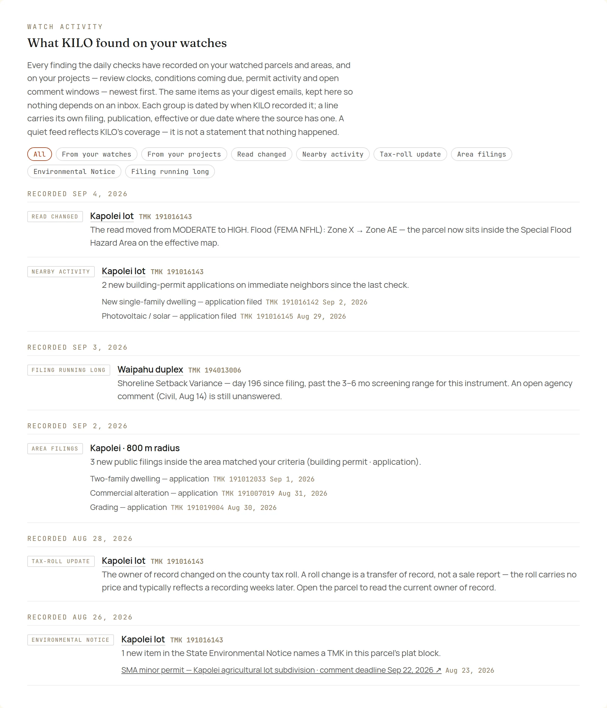
Put a parcel, an area, or a whole list on watch and KILO re-reads it daily, emailing one digest only when something actually changes — and writing every finding to an in-app activity record, so a missed email is never a missed notice.
One digest. Every feed.
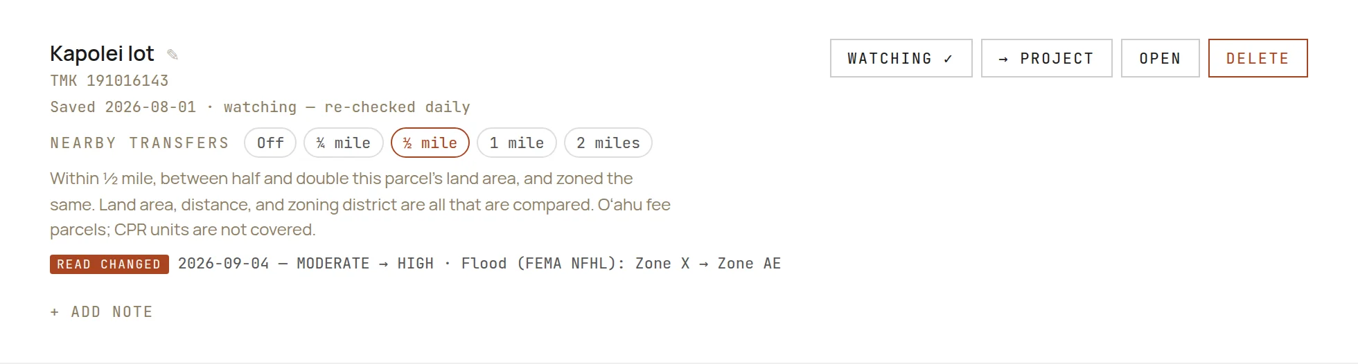
The risk tiers and bands themselves. New permit and application activity on the parcel and its immediate neighbors. A change in the owner of record on the county tax roll — and, at a radius you set, the same transfer on nearby parcels of a similar size and zoning. New Environmental Notice items naming the parcel's plat block, with the comment deadline. Land-use-code amendments that reach the parcel. And a parcel that stops meeting one of your own saved acquisition criteria. The permit, tax-roll and transfer feeds cover Oʻahu fee parcels today; the Environmental Notice feed is statewide.
- Arming a watch takes a baseline first — it never emails you a backlog.
- A quiet feed is stated as coverage, never as nothing having happened.
- A tax-roll change is a transfer of record, not a sale report — the roll carries no price.
Watch an area, not a parcel
Draw a radius around a point, pick the filing types you care about, and new public filings inside it join the same daily digest — reported as filed, not as parcels matching a profile. Oʻahu filings; a quiet week elsewhere is a gap in coverage, never a claim that nothing was filed.
Watch a list you bring
Paste the candidates you already have — your own MLS saved-search alert, or your broker's list — and KILO watches them the same way, on the same digest. It re-reads the parcels you bring; it never ranks anyone's land by cultural sensitivity.
Watch against your criteria
Point a watched parcel at a saved acquisition-criteria set and the digest reports each criterion that changes state — with the reading behind it and the threshold you set. A criterion that could not be checked is reported as coverage, never as a miss.
Turn the read into a development workspace.
One add-on, everything below included — no base-versus-Pro split. It answers what a parcel supports by right, what the deal pencils to on your own numbers, and what the public record says — and lets you ask about the read in plain language.
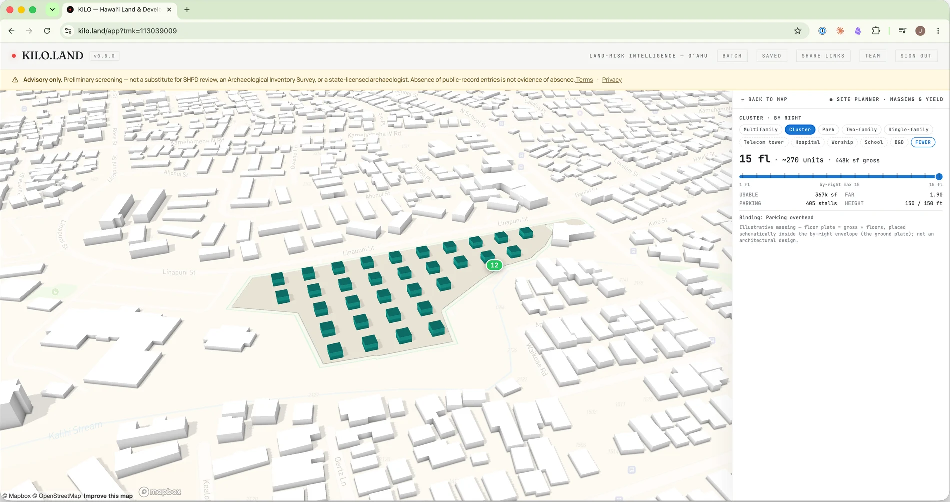
A 3D massing tool you can dial
Launch the by-right massing on the parcel, then drive it: switch the use, drag the stories, and watch units, usable area, parking and FAR move together — with the binding constraint named and an over-the-cap crossing flagged.
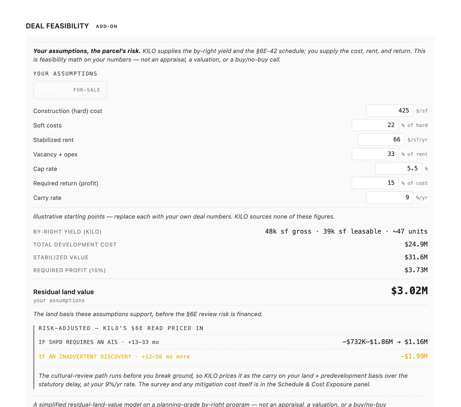
Deal feasibility on your own numbers
Your hard cost, soft cost, rent, cap rate and required return; KILO's by-right yield and §6E schedule. It solves for the residual land value the deal supports — math you control, not an appraisal or a recommendation on whether to purchase.
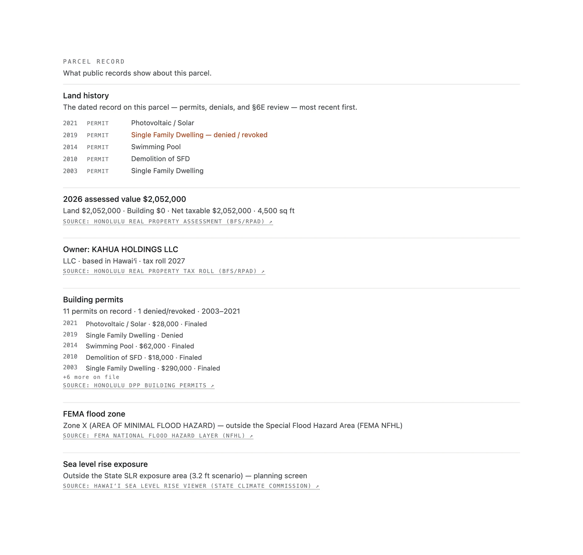
The parcel's public record, assembled
Owner of record, assessed value, the full permit history including the applications denied or revoked, §6E reviews, Environmental Notice items, mapped wildfire burn history, flood and sea-level-rise screens — each line a click from its government source.
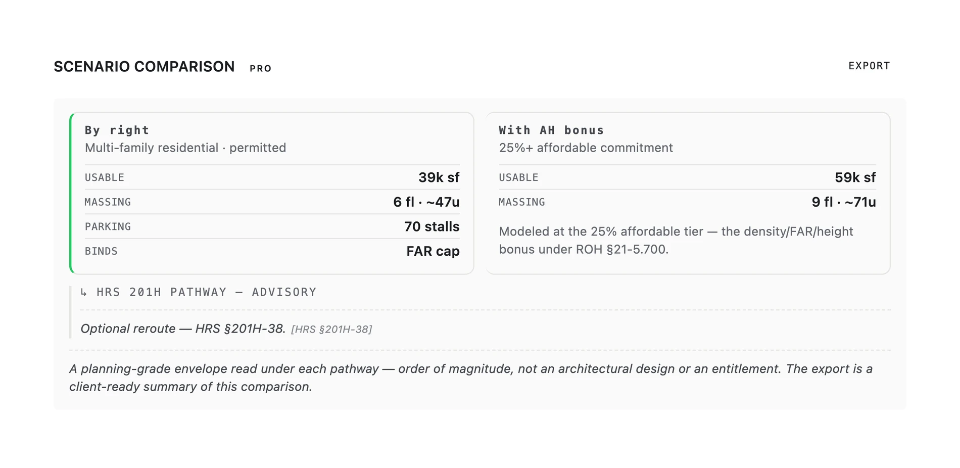
By-right vs. affordable bonus, side by side
The by-right envelope against the affordable-housing-bonus scenario and the HRS 201H pathway in one card — usable area and units for each, and the constraint that binds the by-right envelope. One click exports it client-ready, with your firm on the “Prepared by” line.
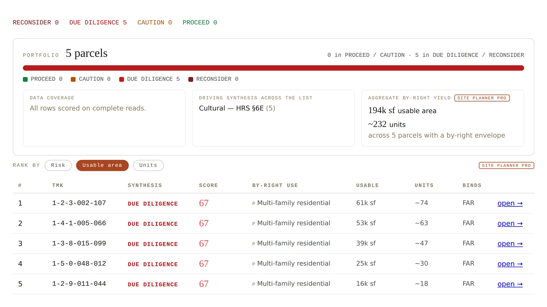
The by-right program across a whole list
Paste a list of TMKs and KILO runs the by-right program on every one, ranked by usable floor area or unit yield with the binding constraint per row — and unions adjacent lots you select into one site to solve the merged envelope.
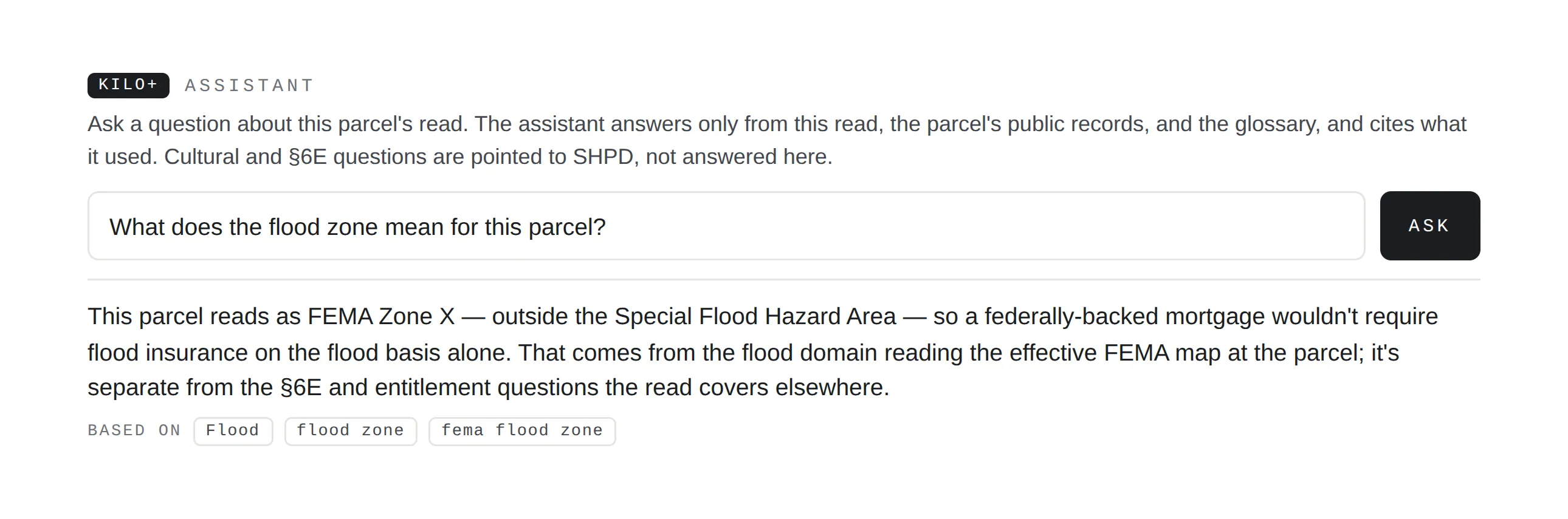
The Kilo+ Assistant — grounded, and cited
Ask about the read in plain language. It answers only from this read, the parcel's public record and the glossary — in the parcel's own county — and shows the sources it used. It says what it could not check, declines rather than guesses, and points cultural and §6E questions to SHPD, never answering them as a clearance. In the workspace it grounds in the tracked project, and asking costs no assessment.
Hand off a finished read.
Every read exports to the document the next person in the deal expects — a working file for diligence, a deck for a landowner, a one-pager for a lender. Each is composed from the same cited read on screen; nothing is re-computed or embellished.
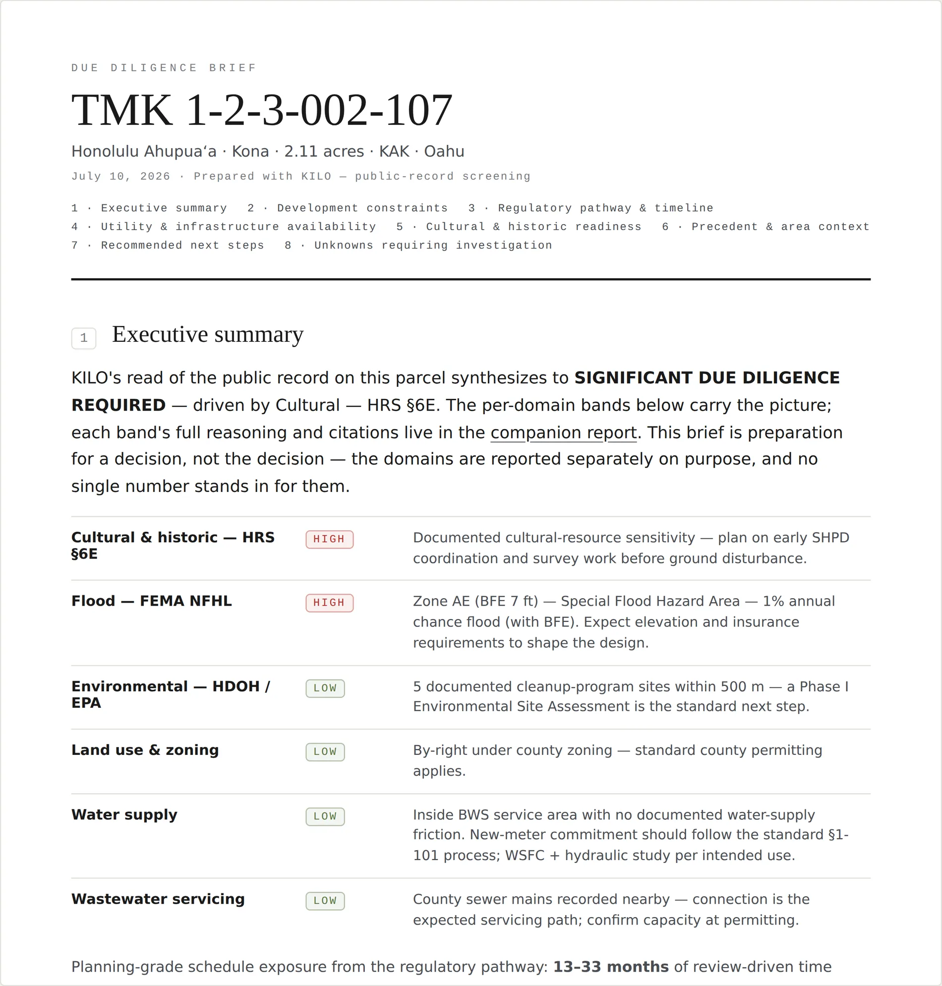
A long-form brief for the deal file.
The letter-format document a diligence file expects: an executive summary with the per-domain bands, development constraints, the regulatory pathway and timeline, utility availability, a cultural and historic readiness section, and a closing register of the unknowns the public record can't close — each paired with the instrument that closes it.
- Per-domain bands with reasoning — never collapsed into one number.
- Cultural & historic readiness — what to be ready for, never a clearance.
- A register of unknowns, each with the instrument that closes it.
Full report PDF
The complete cited read — verdict, band, and every decision question with its sources — rendered to a shareable PDF. A revocable read-only link comes with Solo and above.
Presentation Summary
A landowner-facing slide-deck PDF of the same read — the version you put in front of a seller or a partner who wants the picture, not the appendix.
Pre-Acquisition Brief export
The yield, cultural-review risk, entitlement and schedule summary as a polished one-page client document, with the site constraints and the discovery-conditional detail.
Your firm on the document
Set a company on your account and the Kilo+ client exports — the Pre-Acquisition Brief and the scenario comparison — carry a “Prepared by” line under the header: your firm on the page you hand a client, with the read itself still KILO's.
The read, inside your own tools
An MCP server lets an assistant your team already uses pull the same scrubbed read, a cost preflight, and your own projects and watched parcels — read-only, over your own credential, so your plan's entitlement applies exactly as in the app. A published field guide at kilo.land/semantics.json says what every field means, so a program can't misread a silent domain as an all-clear.
The rest of the due-diligence picture.
Every full read carries the feasibility and regulatory context a Hawaiʻi parcel turns on — drawn from the authoritative sources, and never folded into a single go / no-go number.
Every plan, at a glance.
A single read, a monthly seat, or a firm's shared workspace — and Kilo+ on top of any of them.
| Feature | Included readGoogle sign-up · 14 days | Per assessment$50 / parcel | Solo$150 / mo · 10 reads | Studio & Teamquoted · unlimited |
|---|---|---|---|---|
| Headline band, verdict & what could not be checked | Included | Included | Included | Included |
| The full cited read — six questions, sources, disturbance footprint | Not included | Included | Included | Included |
| Full report PDF | Not included | Included | Included | Included |
| Decision Brief — the cross-domain synthesis | Not included | Included | Included | Included |
| Shareable read-only link, schedule & cost exposure, feasibility companions | Not included | Not included | Included | Included |
| Projects — pathway, clocks, checklists, comments, conditions | Not included | Not included | Included | Included |
| Watch — parcel, area, list, criteria | Not included | Not included | Included | Included |
| Batch assessment, saved screens, criteria memo | Not included | Not included | Included | Included |
| Presentation Summary & Due Diligence Brief | Not included | Not included | Included | Included |
| Market screener | Not included | Not included | Not included | Included |
| One shared pipeline for every seat | Not included | Not included | Not included | Included |
| Kilo+ add-on · $199/mo · attaches to any plan | ||||
| By-right program & 3D massing | Not included | Included with Kilo+ | ||
| Deal feasibility — residual land value on your numbers | Not included | Included with Kilo+ | ||
| Parcel Record, scenario comparison & Pre-Acquisition Brief export | Not included | Included with Kilo+ | ||
| Adjacent-parcel assembly & the Kilo+ Assistant | Not included | Included with Kilo+ | ||
| Portfolio massing — yield ranking across a list (batch tool) | Not included | Not included | Included with Kilo+ | |
Enterprise — lenders, title insurers, government, and large firms — adds unlimited seats, API access and SSO, data licensing, and custom terms, from $42K / yr · scoped per deal.
You bring the parcels. KILO brings the read.
A screening read, cited to the public record, in minutes — so you show up to consultation, to the lender, and to the agency earlier and better prepared.