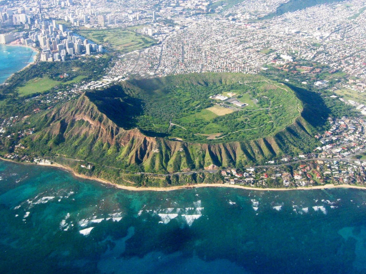
Aerial of Diamond Head and the Honolulu coastline — the kind of Hawaiʻi parcel KILO reads, one at a time.
Pre-development risk intelligence · Hawaiʻi

The land-risk profile of any Hawaiʻi parcel, before you commit.

Whatever you're about to do with a parcel — buy it, build on it, lend against it, insure it, or close on it — read it first. Enter an address or TMK and KILO reads the parcel across every domain that bears on it: entitlement, permitting, water, site, environmental, and cultural-resource. One cited read, with the reasoning shown. Statewide across all four counties; deepest on Oʻahu.

Scroll to read the parcel
TMK 1-1-1-001-001MODERATE 52· HonoluluTMK 1-1-1-002-002MODERATE 48· HonoluluTMK 1-1-1-002-006HIGH 67· HonoluluTMK 1-1-1-002-008MODERATE 55· HonoluluTMK 1-1-1-002-012MODERATE 41· HonoluluTMK 1-1-1-001-001MODERATE 52· HonoluluTMK 1-1-1-002-002MODERATE 48· HonoluluTMK 1-1-1-002-006HIGH 67· HonoluluTMK 1-1-1-002-008MODERATE 55· HonoluluTMK 1-1-1-002-012MODERATE 41· HonoluluTMK 1-1-1-001-001MODERATE 52· HonoluluTMK 1-1-1-002-002MODERATE 48· HonoluluTMK 1-1-1-002-006HIGH 67· HonoluluTMK 1-1-1-002-008MODERATE 55· HonoluluTMK 1-1-1-002-012MODERATE 41· Honolulu
4
Counties — statewide land-use & zoning, by-right to discretionary
6
Islands covered — deepest on Oʻahu
39
Cited public data layers, inspectable and reproducible
Minutes
From an address or TMK to a cited read

Most land risk in Hawaiʻi is found the expensive way — after the purchase, the permit, or the first day of excavation, when zoning, a failing cesspool, a flood line, a shoreline setback, or a cultural-resource issue reshapes the schedule and the budget. KILO reads the parcel before the decision — you bring the parcel, KILO brings the read.

The problem

Land-risk is discovered, not assessed.

The usual workflow is backwards. Someone commits first — signs the purchase, permits the ADU, quotes the foundation, breaks ground — and only then finds out whether a discretionary permit, a failing cesspool, a shoreline setback, a flood line, or a cultural-resource issue will reshape the timeline, the budget, or the project itself. The gap is always the same: nobody read the parcel before the decision was made.
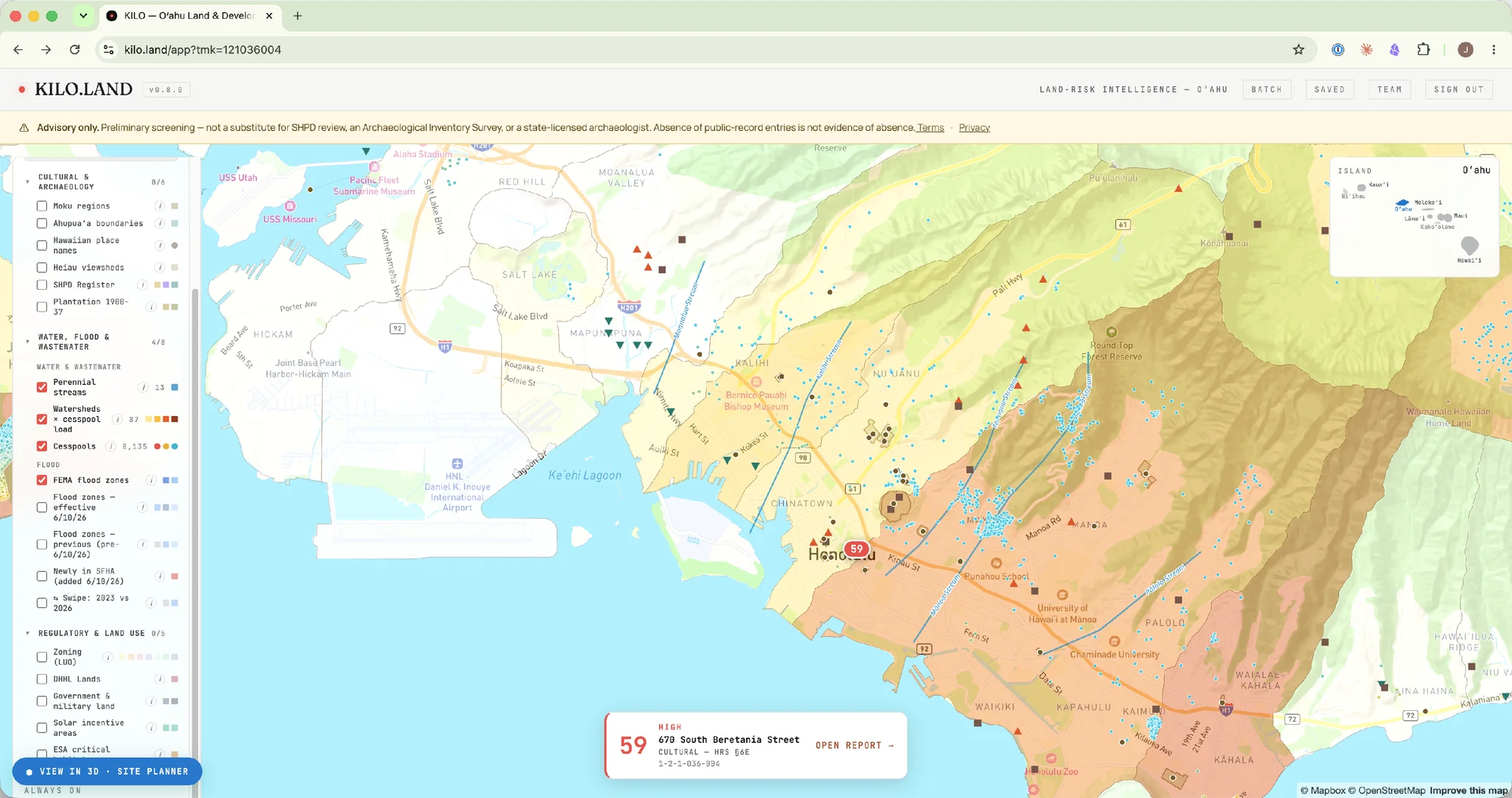
The KILO app: an Oʻahu map with cultural, water, flood, and regulatory data layers toggled in the side panel, site markers across the island, and a parcel scored 59 with an open-report link.
The KILO layer — any parcel read against the public data that decides a build, before the decision is made.
The current process
Site investigation happens after capital is committed. Permit-stage discoveries freeze projects. Community trust erodes. Budgets break.
The KILO layer
A pre-decision signal. Before the purchase, before the entitlement, before the engagement of a consulting firm. Parcel-level, reasoned, and cited.
What it answers

The questions a deal turns on — answered, per parcel.

In plain terms: can you build what you want here, who has to approve it, what's going to be slow, what's going to be expensive, and what could kill the deal — a plain-language brief your whole deal team can read in minutes. Each answer traces to a cited public source, considered at diligence, not found out in the trench.

The decision brief, in detail
The decision brief · an illustrative parcelIllustrative — not a live read
Can you build what you want here?Not by-right — the use you want needs a Conditional Use Permit in this zone, a discretionary hearing before the project is entitled.DISCRETIONARY
Who has to approve it?Three bodies — a county building permit, the CUP hearing, and an SMA permit — two of them discretionary, not ministerial.3 AGENCIES
What's going to be slow?The CUP hearing and SMA review stack to roughly 12–18 months before a building permit can issue — here the schedule, not the price, is the binding constraint.12–18 MO
What's going to be expensive?A documented cesspool forces an Act 125 conversion at 8–10 ft of excavation — budget the conversion, and the deeper discovery contingency that depth implies.CONVERSION
What could kill the deal?A flood AE zone on the parcel edge and a historic property registered within 250 m — both flagged to verify before the LOI. Where the public record is silent, KILO says verify, never clear.VERIFY
Illustrative figures, not a specific parcel — this is the shape of what KILO returns. Your parcel's answers depend on its zoning, location, and existing infrastructure; run it for the live read. Cultural-resource exposure is one input among these, surfaced where the parcel warrants it. Every answer traces to a public, cited source.
What discovery costs

The cost of finding out late.

Before you commit, the cost of knowing is information. After you commit, it's operations — every frozen day burns capital already deployed. KILO sits in the cheap window, upstream of formal due diligence, where you're still choosing whether to pursue a parcel at all.

Pre-decision diligence options · typical industry rangesCost · Time
KILORecommended$299 per assessmentMinutesCited risk indicator + PDF report
Phase I ESA$2,000–$5,0002–3 weeksASTM-standard environmental report
Archaeological Inventory Survey (Hawaiʻi)$15,000–$200,000+2–12+ monthsSHPD-grade archaeological report
KILO is preliminary screening — not a substitute for an AIS or SHPD review. It sits upstream of those formal studies, in the pre-decision window — before anyone commits to the full workup at all. See the full comparison →
The documented discovery record
Documented mid-construction discovery events · OʻahuPublic record · all post-2000
Park at Keʻeaumoku · 2022Inadvertent discovery during development of a 972-unit, two-tower project. Reburial in place required, project redesigned, multi-year litigation — a costly mitigation path before the design loss.TOWER
Walmart Keʻeaumoku · 2003Mid-construction inadvertent discovery prompted forced design changes, public dispute, and lasting reputational impact. The project shipped — but at a cost no one had priced in.RETAIL
Kawaiahaʻo Church · ongoingMultifunction-building project halted indefinitely after an inadvertent discovery. Multi-decade litigation, durable damage to community trust.INSTITUTIONAL
Cesspool conversions in coastal substrateForced cesspool conversion in sand-substrate coastal soils has produced inadvertent discoveries on Kauaʻi (Wainiha 2021) and on Oʻahu. Act 125 mandates conversion or upgrade of all Hawaiʻi cesspools by 2050; most are homeowner-class projects.RESIDENTIAL
It is not a one-off — the same root cause across the decades. The buyer of a 5,000 sq ft Lanikai lot, the homeowner converting a Hauʻula cesspool, and the developer entitling a Kakaʻako tower face different dollar amounts, but the same structural risk.
Case study · Retrospective hindcast
Two Keʻeaumoku blocks, two discoveries — what KILO returns for each
We ran the Walmart and The Park parcels back through the engine as an honest retrospective — the reads, step by step, including what the engine could not confirm.
Capabilities

What the tool does, specifically.

One parcel in, one cited read out — enough to size up any parcel before committing to the full workup, with the reasoning shown. Built from live authoritative data; designed to slot in alongside the consultants and agency review you already use.
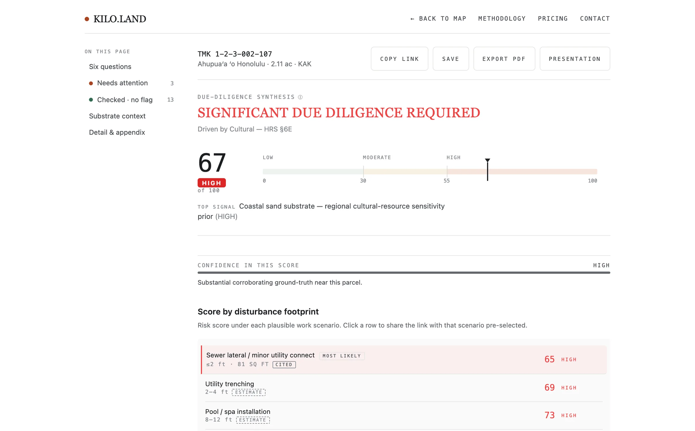
A KILO report: a due-diligence verdict with a 0–100 score and band, the score by disturbance footprint, and the six decision questions answered with cited sources.
The report — a verdict, a score with its reasoning, and the six decision questions answered, each traced to a cited source.
01
Parcel-level risk score, with reasoning.
A layered set of inference rules produces a score, a confidence signal, and a fully-traced explanation of which factors fired. Never a black box.
02
Live data from authoritative sources.
Statewide ahupuaʻa and moku polygons from Hawaiʻi Statewide GIS (OHA/SHPD), USDA SSURGO soil data, live parcel boundaries across all four counties, and historic imagery overlays (Oʻahu, 1881 / 1899 / 1938).
03
Built to complement your team.
Pre-fieldwork screening — designed to slot in alongside the consulting firms, agency review, and statutory-consultation processes that already exist. Absence of public-record entries is never interpreted as safety.

And the read is only the start. With the Site Planner add-on, KILO becomes a development workspace: what's buildable by right, a 3D massing model on the map, and deal feasibility that solves for the residual land value your own numbers support — with the §6E cultural-review risk priced in. Site Planner Pro adds scenario comparison, client-ready exports, and portfolio batch massing. And the Parcel Record assembles the public record — assessed value, permit history, hazard screens — so you don't pull it from six government portals yourself.

A
A full feasibility read.
Every read carries the rest of the picture — entitlement and zoning across all four counties, wastewater and water supply, terrain, energy and renewable siting, coastal and sea-level-rise exposure, and the mapped site-alteration record on 379,000 parcels statewide. Feasibility context, drawn live; never a composite go/no-go.
B
A portfolio workflow.
Bring a list, not just a parcel. Filter the parcels you brought by market and regulatory bands into saved screens, put any of them on watch for a daily re-read, and — with Pro — batch the by-right program across the list or combine adjacent lots into one site.
C
Finished deliverables.
Export the read as the document the next person expects — the full cited PDF, a landowner Presentation Summary, or a long-form Due Diligence Brief for the deal file, each with a closing register of the unknowns the public record can't close.
The four methods

Four discrete methods. One parcel-level read.

Every assessment runs four named methods over the parcel — a regulatory cascade, a ground-disturbance profile, a cultural-resource screen, and a procedural-readiness pathway. Cite them in your scope of work; review each on the report. All paid tiers include all four — there are no method-gated tiers.

01
KILO Compliance Matrix
Every statute and overlay that touches the parcel, surfaced as a cascade — county zoning (Honolulu ROH ch. 21, plus the Kauaʻi, Maui, and Hawaiʻi county codes), HAR §11-62 + Act 125 (wastewater), shoreline setback, FEMA NFHL (flood), CWA §401/§404 (federal water), SMA (coastal permit), HRS §6E (SHPD), DOH HEER, TOD, DHHL. Cited and inspectable per row.
02
KILO Substrate Profile
Empirical ground-disturbance risk profile — coastal sand substrate, soil drainage class, prior-disturbance footprint, depth-by-scenario. Calibrated against the documented Oʻahu inadvertent-discovery record (Kakaʻako, Wainiha, Keʻeaumoku, Kawaiahaʻo).
03
KILO Cultural Screen
Pre-fieldwork sensitivity read on cultural-resource exposure — SHPD Historic Register, public-record cultural-property density, cemetery proximity, plantation-era disturbance, ahupuaʻa context, and DHHL trust-land context. Scoped to pre-consultation screening under HRS §6E-42; never a substitute for a state-licensed archaeologist.
04
KILO Mitigation Pathway
The procedural next steps, by band — recommended SHPD coordination, Ka Paʻakai readiness (Ka Paʻakai O Ka ʻAina v. LUC, 94 Hawaiʻi 31, 2000), Burial Council consultation thresholds, contingency-budget guidance. Keyed to what the parcel actually triggers, not a generic checklist.
Principled stance
What we won't do.
KILO does not ingest, aggregate, or store data that localizes iwi kūpuna — from any source. We use what records-holders publish under HRS §6E-43.5(f); we do not rebuild what they redact. Cultural-resource sensitivity is modeled from public empirical correlates — never as a presence claim at any specific point. Read the full burial-data policy →
Who it's for

Seven buyers. One parcel-level read.

The exposure on a parcel is the same fact for everyone — but the decision it informs is not. Each buyer reads it differently; pick the door that matches yours.

Developers
Developers & acquisition teams
Know the full exposure on a parcel — entitlement and land-use feasibility, water (wastewater + supply + quality + federal permits), shoreline, energy availability, cultural-resource (with Ka Paʻakai readiness), and the regulatory cascade — before the purchase agreement is signed. Price it into the deal, or walk away.
Explore →
Architects
Architects & planners
Frame scope, fee, and schedule at feasibility with a parcel-level read on water (cesspool mandate + supply feasibility + federal CWA §401/§404 / NPDES Construction triggers), shoreline-setback, cultural-resource, and regulatory exposure — before the contract locks in a timeline.
Explore →
Renewable Energy
Renewable energy developers
Site solar, wind, storage, or a colocated data-center load with a parcel-level read on grid-infrastructure access (HIFLD transmission + substations), solar yield (NREL PVWatts), developable terrain (lidar slope), hosting-capacity and interconnection-queue posture (HECO LVM + IIQ deep-links), IRA §48E energy-community incentive context, cultural-resource and Ka Paʻakai exposure, and water and shoreline constraints — rolled into one renewable-siting read before committing capital to a parcel that can't actually connect or can't actually be permitted.
Explore →
Homeowners & Brokers
Homeowners, brokers & contractors
Screen a single parcel before a contract — water, shoreline, rooftop-solar potential, and cultural-resource — and use the implied cost and delay as leverage to negotiate the price down, or walk.
Explore →
Title & Escrow
Title & escrow
Add water (cesspool mandate + supply feasibility + federal §401/§404), shoreline-setback, and cultural-resource exposure to the parcel screen — cited and fast enough to run on every file.
Explore →
Lenders & Insurers
Lenders & insurers
Price construction-loan and builder's-risk exposure with site-level data — discovery-driven delay, the cesspool mandate, water-supply feasibility (the BWS commitment-letter cycle), federal water-permit triggers, Ka Paʻakai agency-review pathways that add 6-12 months to CDUP / SMA timelines, grid + energy-infrastructure access, and buildable-area loss under sea-level rise.
Explore →
Government
Agencies & planning departments
Screen parcels at portfolio scale — CIP pipelines, acquisition lists, permit queues — with every conclusion cited to a public source.
Explore →
What you'd use it for

Eight jobs. One parcel-level read.

The industry cards above are about who you are. These are about what you do with it — the same cited assessment, put to work across the deal lifecycle and the risks that define a Hawaiʻi parcel.

Use case
Acquisition & LOI screening
Get a parcel-level risk read before the letter of intent — so the number you put on the table already prices the exposure.
Explore →
Use case
Pipeline screening
Run the same cited read across the candidate parcels you're weighing — a shortlist of five or a pipeline of fifty — ranked by exposure before diligence picks a finalist.
Explore →
Use case
Loan & title underwriting
Add water (wastewater + supply + quality + federal permits), shoreline, and cultural-resource exposure to the construction-loan and title underwriting file.
Explore →
Use case
Portfolio review
Run the engine across a whole book of parcels at once and rank holdings, loans, or a land bank by exposure.
Explore →
Use case
Permitting & Section 106 pre-consultation
See which reviews a parcel triggers — HRS §6E-42, the TOD tracks, SMA, Section 106 — before you file, so the cascade is anticipated, not discovered.
Explore →
Use case
Cesspool, wastewater & water screening
Find a parcel's wastewater situation — and what the Act 125 conversion mandate means alongside the BWS, CWRM, SDWA, USACE, and Surfrider water-quality picture for the same parcel.
Explore →
Use case
Flood & FEMA FIRM readiness
Screen a parcel's flood posture — current FEMA zone and base flood elevation — and its exposure to the June 2026 FIRM update that re-maps thousands of Oʻahu parcels.
Explore →
Use case
Energy & grid-interconnection feasibility
Screen a parcel for grid-infrastructure access (HIFLD transmission + substations), solar yield (NREL PVWatts), developable terrain (lidar slope), IRA §48E energy-community incentive context, and hosting-capacity posture (HECO LVM + IIQ deep-links) — rolled into one banded Renewable Siting read, before the interconnection study tells you no.
Explore →
How it reasons

Cited rules over public data — not a black box.

KILO reads a parcel with a layered set of cited rules over public data, and shows its work — never a black box. It surfaces every domain that bears on a build — entitlement, water, site, environmental, and cultural-resource — each as its own cited read, and where the public record is silent it says verify, never clear. Built on 39 publicly-published data layers.

The domains a read covers

Every assessment reads across the same domains — entitlement, water, site, environmental, and cultural-resource — each as its own cited read, with the specific inputs and reasoning shown on the assessment itself. The categories of data behind a read are summarized in Data sources below; the engine weights them differently — some carry a score contribution, others are surfaced as cited context.

How what you build changes the score

Risk depends on what you build, too. Two homes on one parcel carry very different ground-disturbance exposure depending on how much soil they move — a sewer lateral barely touches the ground; a cesspool conversion reaches 9+ feet. Every assessment scores each plausible disturbance footprint, so the buy/no-buy call matches the real project, not the parcel's worst case — and flags the row your parcel's existing infrastructure actually forces as the realistic one.

Worked example · A representative parcelDeeper footprint, higher read
Sewer lateral / minor utility≤2 ft · 81 sq ft · citedLOW
Utility trenching2–4 ft · estimateMOD
Pool / spa installation8–12 ft · estimateMOD
Single-family foundation4–8 ft · estimateMOD
Septic + leach field3–10 ft · 375 sq ft · citedMOD
Full site grading / commercialshallow, wide · estimateMOD
Cesspool replacementREALISTIC9+ ft · estimateMOD
Footprint figures (sewer lateral, septic + leach) from The Hanalei Initiative,
Wastewater Management Plan (Feb 2026). Other scenarios are estimates.
Water & shoreline

The water and shoreline tests that decide a coastal parcel.

Three of the most consequential — and most easily missed — questions on a Hawaiʻi parcel are about water: which wastewater path the parcel forces, whether a septic system still complies as the sea rises, and how much of the lot stays buildable behind the shoreline setback. KILO runs all three from live data, now and at each sea-level-rise step. We say documented deliberately: registered inventories aren't exhaustive, and the app says so when a check returns negative — a clean read is never a guarantee.

Which wastewater path your parcel forces
Wastewater classification · live for every Oʻahu parcelFive outcomes, one signal
Cesspool documented (HCPT 2022)Cesspool replacement · mandatory by 2050 under Act 125HIGH
Cesspool in DOH OSDS only (HCPT gap)Cesspool replacement · older registrationHIGH
Septic or ATU documented (OSDS 2008)Existing on-site · replacement scenario appliesMOD
Sewer mains within ~100mSewer-lateral connection · smallest plausible footprintLOW
No sewer, no on-site documentedLikely septic for new constructionMOD
Cross-references the statewide cesspool inventory (~82,000 documented; 8,135 on Oʻahu, per UH Water Research Center / DOH) · DOH OSDS 2008, septics and ATUs · C&C Honolulu sewer mains. The sewer-main layer is Honolulu-only, so off Oʻahu KILO says county sewer availability isn't mapped — confirm with the county — rather than asserting "no sewer." For a documented cesspool, KILO also reports the HCPT census-block conversion priority — High, Medium, or Low.
When a compliant septic fails by 2050

Hawaiʻi DOH requires three feet of dry soil between a leach field and the water table — HAR §11-62. On flat coastal lots that buffer shrinks as the sea rises: groundwater climbs about a foot for every foot of sea-level rise. KILO projects the separation under each SLR scenario and flags where a system compliant today fails by 2050.

Worked example · A representative coastal cesspool parcelHCPT depth-to-water 2.5 m
Current separationToday1.00 mCOMPLIANT
@ 1.1 ft SLRHanalei 1:1 model0.66 mFAILS
@ 2.0 ft SLRSLR-XA scenario band0.39 mFAILS
@ 3.2 ft SLRSLR-XA scenario band0.02 mFAILS
HAR §11-62 · Hawaiʻi DOH. State SLR-XA scenario bands.
Groundwater-rise model from The Hanalei Initiative, Wastewater Management Plan (Feb 2026);
generalization to coastal Hawaiʻi per Habel et al. 2017 and Honolulu Climate Change Commission guidance.
How much of the lot you can build (Oʻahu)

On Oʻahu, Honolulu's ROH §26-1.4(b) sets a building setback inland from the shoreline, and SMA permits must show the parcel against three sea-level-rise scenarios — numbers that normally take a surveyor and a coastal engineer. KILO intersects live SLR-XA polygons with the parcel and reports buildable area, now and at each SLR step, against the 1,500 sq ft minimum the ordinance protects. (Neighbor-island shoreline setbacks vary by county code.)

Worked example · A representative shoreline-abutting Oʻahu parcelParcel area 4,800 sq ft
Setback encumbered60 ft · ROH §26-1.4(b)1,200 sq ft
Buildable nowToday3,600 sq ftABOVE FLOOR
@ 1.1 ft SLRSetback dominates3,600 sq ftABOVE FLOOR
@ 2.0 ft SLRSLR-XA dominates2,800 sq ftABOVE FLOOR
@ 3.2 ft SLRSLR-XA dominates1,300 sq ftBELOW FLOOR
Phase 1.0 uses the 60 ft baseline setback. Correct for inside the Primary Urban Center and for parcels with accreting / zero-rate shorelines. Outside-PUC high-erosion parcels (notably North Shore) may have a larger statutory setback up to 130 ft per the same ordinance — erosion-rate refinement is the next ship.
Shoreline approximated from the SLR-XA Vegetation Line (2005-2008). A DLNR-certified shoreline survey supersedes for actual permitting.
ROH §26-1.4(b) effective July 1, 2024 · Hawaiʻi Statewide GIS Climate MapServer (SLR-XA, Vegetation Line).
Data sources

Where the reasoning comes from.

Every score is built from public and authoritative sources — 39 data layers plus the published academic record, across the categories below. Each assessment cites the specific inputs behind it and shows its work.

The categories of data behind a read
Land & cultural geography
Ahupuaʻa, moku, and place-name geography, parcel boundaries, soils, and land-tenure context from authoritative state and county sources.
Cultural & historic resources
The State's public historic-register release and mapped cultural-resource context — the properties records-holders publish under HRS §6E-43.5(f).
Wastewater infrastructure
Cesspool, septic, and sewer-service context and the permitted treatment-facility inventory.
Water supply & aquifer regulation
Groundwater-protection zones, aquifer-system designation, and injection-control regulation.
Surface water & coastal quality
Nearshore and stream water-quality monitoring and major ocean-discharge context.
Environmental contamination & hazards
Environmental-contamination dockets and mapped natural-hazard exposure — flood, sea-level rise, and more.
Land use & entitlement
Zoning, special-district, and land-use entitlement context across the counties.
Energy infrastructure
Transmission, substation, and grid-proximity context for feasibility.
Mapping infrastructure
Basemap and geocoding tooling — supporting infrastructure, not a scoring input.
Regulatory framework
The statutes and administrative rules the assessment cites, not a data source it draws from.
Published literature
The published archaeological and settlement-pattern record for Hawaiʻi.
Request access

Tell us about the deal you'd use it on.

Access is invite-only during beta. The more specific you are about the parcel or deal, the faster we triage and the more useful the first conversation. We read everything that comes in.